Another snowstorm is headed towards southern Ontario
Southern Ontario is bracing for yet another round of snow that is expected to create hazardous travel conditions on Friday.
Environment Canada issued a winter weather travel advisory on Thursday ahead of heavy snow tonight through to Friday morning
"A developing low pressure centre will bring a swath of snow to the region tonight into Friday morning," Environment Canada said.
Most areas of southern Ontario are expected to receive between five and 10 centimetres of snow. Snowfall could be heavy at times, Environment Canada says.
"Motorists should expect hazardous winter driving conditions and adjust travel plans accordingly," the weather advisory says. “There may be a significant impact on rush hour traffic in urban areas."
Cornwall, Tweed, Kingston, and Brockville are currently under snowfall warnings, with up to 15 centimetres of snow forecast by Friday afternoon.
The snow is expected to clear by Friday afternoon, but it will remain cold. In Toronto, temperatures are expected to dip down to -16 C overnight Friday, feeling more like -22 C by Saturday morning.


CTVNews.ca Top Stories
'I just can't believe that it took so long': Body found in wreckage 3 months after deadly fire
A man accused of arson in a January Old Strathcona apartment fire is expected to be charged with manslaughter after a body was discovered in the burned building late last month.
No proof man lied to brother about number of kittens born in litter, B.C. tribunal rules
A man was denied a $5,000 payout from his brother after a B.C. tribunal dismissed his claim disputing how many kittens were born in a litter.
Quebec police hand out hundreds of tickets to Hells Angels and other bikers before 'first run' meeting
Quebec provincial police handed out hundreds of fines to Hells Angels members and other supporting motorcycle clubs who met for their 'first run' in a small town near Sherbrooke, Que.
Grandparents killed in wrong-way crash on Hwy. 401 identified
A 60-year-old man and a 55-year-old woman killed in a wrong-way crash on Highway 401 earlier this week have been identified by the Consulate General of India in Toronto.
Auston Matthews skates ahead of Game 7, status unclear with season on the line
Centre Auston Matthews of the Toronto Maple Leafs hasn't been ruled out of tonight's Game 7 against the Boston Bruins.
Snakes almost on a plane: U.S. TSA discovers a bag with small snakes in passenger's pants
According to an X post by the Transportation Security Administration, officers at the Miami International Airport found the small bag of snakes hidden in a passenger's trousers on April 26 at a checkpoint.
A Chinese driver is praised for helping reduce casualties in a highway collapse that killed 48
A Chinese truck driver was praised in local media Saturday for parking his vehicle across a highway and preventing more cars from tumbling down a slope after a section of the road in the country's mountainous south collapsed and killed at least 48 people.
Russia puts Ukrainian President Zelenskyy on its wanted list
Russia has put Ukrainian President Volodymyr Zelenskyy on its wanted list, Russian state media reported Saturday, citing the interior ministry’s database.
Britney Spears 'home and safe' after paramedics responded to an incident at the Chateau Marmont, source tells CNN
A source close to singer Britney Spears tells CNN that the pop star is 'home and safe' after she had a 'major fight' with her boyfriend on Wednesday night at the Chateau Marmont in West Hollywood.
Shopping Trends
The Shopping Trends team is independent of the journalists at CTV News. We may earn a commission when you use our links to shop. Read about us.


Montreal
-

Despite shift to EVs, number of gas-powered cars on Quebec roads hits record high
The province has been pushing drivers to make the switch to electric vehicles (EVs) but it appears Quebecers aren't buying in. The latest numbers from the SAAQ show that the number of gas-powered vehicles hit a record high in 2023.
-
Quebec police hand out hundreds of tickets to Hells Angels and other bikers before 'first run' meeting
Quebec provincial police handed out hundreds of fines to Hells Angels members and other supporting motorcycle clubs who met for their 'first run' in a small town near Sherbrooke, Que.
-
Explosion at train station leads to discovery of stolen car on Montreal's South Shore: police
Police are investigating after a BMW exploded in the St-Lambert Exo train station parking lot on Montreal's South Shore.
Ottawa
-

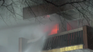
Firefighters battle second Overbrook highrise blaze on Donald Street
Ottawa Fire Services say crews battled a fire that broke out in the bedroom of an Overbook highrise on Friday evening - less than 48 hours after a fire in the same building displaced hundreds of residents and sent three people to hospital in critical condition on Thursday.
-
Outdoor Farmers' Market back in Ottawa this May
The Ottawa Farmers' Market is bringing back its outdoor markets this May, featuring fresh produce sold by local vendors across five different locations in the city.
-
The pros and cons of discussing mental health issues in the workplace
A group of lawyers has written what they call a groundbreaking book about how mental health is perceived in the legal profession.
Northern Ontario
-

Northern Ont. man guilty of three counts of first-degree murder in Sudbury firebombing
The jury deciding the fate of a man responsible for a fatal firebombing in Sudbury found him guilty of three counts of first-degree murder Friday afternoon.
-
Grandparents killed in wrong-way crash on Hwy. 401 identified
A 60-year-old man and a 55-year-old woman killed in a wrong-way crash on Highway 401 earlier this week have been identified by the Consulate General of India in Toronto.
-
Police find human remains in remote northern Ont. hamlet
Shortly after 9 a.m. on May 3, Ontario Provincial Police (OPP) found human remains in a wooded area near Katrine, Ont.
Kitchener
-

WRDSB to lay off 106 elementary school teachers
More than 100 teachers at the Waterloo Region District School Board (WRDSB) are learning they have been declared surplus will likely be out of a job as of Aug. 12.
-
Chemical spill could be cause of stinky water in Puslinch, Ont., new report says
People living in Puslinch, Ont. may have the answer to why their water smelled so bad last year.
-
Grandparents killed in wrong-way crash on Hwy. 401 identified
A 60-year-old man and a 55-year-old woman killed in a wrong-way crash on Highway 401 earlier this week have been identified by the Consulate General of India in Toronto.
London
-

May the 4th strikes back: Geeks and Co. holding Star Wars event to raise money for charity
May the 4th traditionally marks Star Wars Day, and some London, Ont. area fanatics are expressing their love for the movie franchise.
-
Olympic talent scouts arrive in the Forest City for annual 'RBC Training Ground'
The Canadian Olympic Committee hosted a free talent search in London, Ont. Saturday.
-
CTV News London's top stories from this week
In case you missed it, CTV News London has compiled all the top local stories from this week into one video for your convenience.
Windsor
-

CTV News Windsor's top stories from this week
In case you missed it, CTV News Windsor has compiled all the top local stories from this week into one video for your convenience.
-
Teen charged in connection with armed robbery
The Windsor Police Service has arrested a 17-year-old boy following an armed robbery in the city’s west end.
-
Grade 6 student saves choking classmate
A lesson learned at school saved a life Thursday.
Barrie
-
Two people charged as OPP recover stolen firearm in Orillia
OPP have laid multiple firearms related charges against two individuals in Orillia.
-
Man in custody after alleged intimate partner violence
A Barrie man is facing multiple charges related to incidents of intimate partner violence that originated in the Township of Essa.
-
Hunreds take part in the annual Charlee's run fundraiser
The annual Charlee's run fundraiser returned to Orillia on Saturday.
Winnipeg
-

Winnipeg man wanted for murder arrested in Saskatoon
A 28-year-old Winnipeg man wanted for murder was arrested near Boychuk Drive and Briarwood Road in Saskatoon.
-
‘We needed this rain’: Farmers welcome wet weather as seeding season gets underway
Greener pastures may be on the horizon for Manitoba farmers who say the recent rainfall has put them in good shape for this year’s growing season.
-
2 charged after police find 'concerning and diverse' explosives at Manitoba home
Winnipeg police say they have arrested two people in their 20s after a large amount of explosives were found in a home outside of Winnipeg, Man.
Atlantic
-

Nova Scotia NDP leader says party is election ready, announces housing plan
Nova Scotia's NDP leader announced a program aimed at easing the cost of housing during a rousing campaign-style speech before the party's annual convention in Halifax today.
-
15-year-old boy dies following ATV collision: N.B. RCMP
A 15-year-old boy, from the Bathurst region, has died following an all-terrain vehicle (ATV) collision in Beresford, N.B.
-
Upper Musquodoboit man dies after car leaves road: N.S. RCMP
RCMP said they responded to a report of a single motor vehicle crash on Highway 289 on Wednesday around 10:09 p.m.
N.L.
-

Funeral today for broadcasting legend and voice of 'Hockey Night in Canada' Bob Cole
A funeral is being held today for hockey broadcasting legend Bob Cole in his hometown of St. John's, N.L.
-
Newfoundland fisherman says police broke his leg during protest that delayed budget
Richard Martin is spending this year's fishing season on land after he says a Royal Newfoundland Constabulary officer broke his left leg in three places during a protest last month that shut down the provincial legislature.
-
'I feel honoured to say I was his friend': Wayne Gretzky remembers Bob Cole
Tributes continue to pour in for Bob Cole as his family has confirmed a funeral will be held for the legendary broadcaster Friday in St. John's, N.L.
Edmonton
-

Oilers to face Canucks in second round of NHL playoffs
The Edmonton Oilers will face the Vancouver Canucks in the second round of the National Hockey League post-season after Vancouver advanced with a 1-0 win over the Nashville Predators in Game 6 Friday, winning the best-of-seven opening-round series 4-2.
-
Netflix is filming a western series in Calgary starting this month
Netflix is set to begin filming a western series with a star-studded cast in Calgary this month. The Abandons, created by Kurt Sutter from Sons of Anarchy fame, follows “a group of diverse renegade families living on the fringes of society in 1850s Oregon.”
-
'I just can't believe that it took so long': Body found in wreckage 3 months after deadly fire
A man accused of arson in a January Old Strathcona apartment fire is expected to be charged with manslaughter after a body was discovered in the burned building late last month.
Calgary
-

Netflix is filming a western series in Calgary starting this month
Netflix is set to begin filming a western series with a star-studded cast in Calgary this month. The Abandons, created by Kurt Sutter from Sons of Anarchy fame, follows “a group of diverse renegade families living on the fringes of society in 1850s Oregon.”
-
TransAlta cancels wind power project over new government rules on development
A major Alberta utility has cancelled a large wind power project in response to new government rules on where such developments can be built.
-
Parliamentary report on Emergencies Act decision is 18 months past due — and counting
The erstwhile group of senators and MPs studying the federal government's invocation of the Emergencies Act over the "Freedom Convoy" was supposed to present its findings in December. December of 2022, that is.
Regina
-

Human remains found in rural Sask. possibly a decade old, RCMP say
RCMP say human remains found in a rural area in central Saskatchewan may have been there for a decade or more.
-
Sask. Party raises $3.6M, leads in donations ahead of looming election call
Premier Scott Moe's Saskatchewan Party has received millions of more dollars in donations compared with rivals ahead of this year's election.
-
Some sunshine on the way for Regina this weekend
After some gloomy and rainy days in the Queen City, there will be some sunshine heading into the weekend.
Saskatoon
-
Winnipeg man wanted for murder arrested in Saskatoon
A 28-year-old Winnipeg man wanted for murder was arrested near Boychuk Drive and Briarwood Road in Saskatoon.
-
Deflated for now, Saskatoon's Golf Dome is about to get a makeover
A lesser known fixture of Saskatoon's skyline is coming down for repairs and renovations.
-
Minten’s dagger halts Warriors' late-game comeback, chance to advance for Blades
The WHL Eastern Conference Final between the Saskatoon Blades and Moose Jaw Warriors has been full of see-saw momentum shifts, heart-stopping moments, and overtime heroes. Game 5 had all of the above.
Vancouver
-

Red dresses to make fashion statement about missing and murdered Indigenous women
Models in uniquely designed red dresses are taking to the runway in British Columbia this weekend to make a powerful fashion statement about missing and murdered Indigenous women, girls and two-spirit people.
-
No proof man lied to brother about number of kittens born in litter, B.C. tribunal rules
A man was denied a $5,000 payout from his brother after a B.C. tribunal dismissed his claim disputing how many kittens were born in a litter.
-
Suter scores late goal, clinches series for Canucks
Pius Suter scored with 1:39 left and the Vancouver Canucks advanced to the second round of the NHL playoffs with a 1-0 victory over the Nashville Predators on Friday night in Game 6.
Vancouver Island
-

No proof man lied to brother about number of kittens born in litter, B.C. tribunal rules
A man was denied a $5,000 payout from his brother after a B.C. tribunal dismissed his claim disputing how many kittens were born in a litter.
-
Red dresses to make fashion statement about missing and murdered Indigenous women
Models in uniquely designed red dresses are taking to the runway in British Columbia this weekend to make a powerful fashion statement about missing and murdered Indigenous women, girls and two-spirit people.
-
Suter scores late goal, clinches series for Canucks
Pius Suter scored with 1:39 left and the Vancouver Canucks advanced to the second round of the NHL playoffs with a 1-0 victory over the Nashville Predators on Friday night in Game 6.


