'Something you'd see in a hurricane:' Toronto saw more than a month's worth of rain in three hours
In the span of three hours, Toronto was hit by three thunderstorms, bringing a record amount of rain that caused massive flooding across the city, according to a senior meteorologist with Environment Canada.
"July is typically the second rainiest, second wettest month. Well we had 25 per cent more rain in three hours than we'd have normally in the whole month of July with all the thunderstorms and systems that moved through," Meteorologist Dave Phillips said in an interview with CP24 Tuesday afternoon.
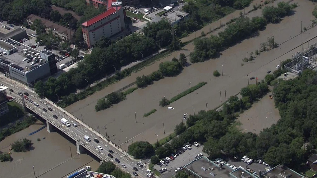
 This aerial image shows vehicles that were abandoned on the Don Valley Parkway amid flooding on July 16. (CP24)
According to Environment Canada, Toronto usually sees 71.6 millimetres of rain for the whole month and Phillips said 96 millimetres of rain was already recorded at Toronto Pearson Airport as of 2:30 p.m. The storm also broke the previous rainfall amount for July 16 documented in 1941, when 25.9 millimetres of rain fell.
"Three thunderstorms in three hours with heavy rains. Now, in a thunderstorm, you can sometimes get no rain. It can thunder and lightning but no rain, or you can get a little bit of rain, but these were like gully washers just one hour after hour," Phillips said.
"This is a record for this day. I'm never impressed by the amount of breaking records on a day, but the previous record for this day, July 16, was only a quarter of what we saw today in three hours."
FOLLOW LIVE: WIDESPREAD FLOODING ACROSS THE GTA, NUMEROUS ROADS CLOSED
Phillips described Tuesday's weather system as a "freight train" that lined up from London, Ont. right through the west of Toronto. He said it moved slowly in a straight line with a pipeline of moisture from the Gulf of Mexico.
It began just before 9 a.m. and lasted until around 1 p.m. Several weather advisories, including severe thunderstorm warning and rainfall warning, were issued as the system moved through the region.
"In fact, what tells me how intense it was -- we saw maybe 30 millimetres in 30 minutes, which is something you'd see in a hurricane, but the amount of rain, you could tell it was heavy because of the visibility. We went from 16 kilometre per hour in terms of visibility down to less than two," Phillips said.
"It was hard to see across the street because the rain was so intense. It was like a blizzard of rain coming down, and you couldn't see it."
The torrential downpour resulted in flooded highways and roads, transit services being disrupted and hundreds of thousands of hydro customers without power.
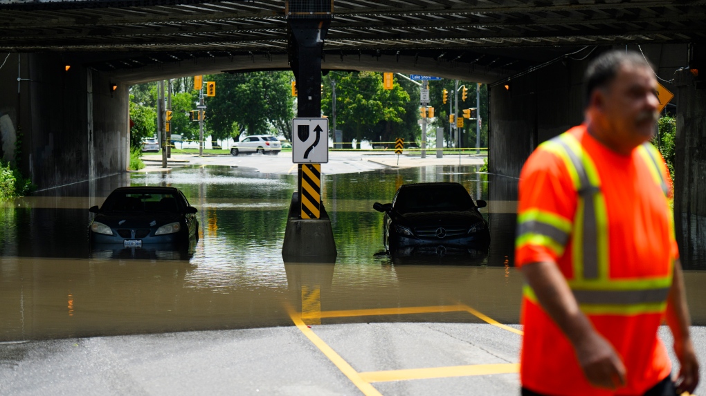
 A tow truck operator responds to submerged vehicles at an underpass at Parkside Drive and Lake Shore Blvd., after heavy rain caused flooding, in Toronto on Tuesday, July 16, 2024. THE CANADIAN PRESS/Christopher Katsarov
Phillips said the city was already well "watered" before Tuesday's storm as it's been a wet spring and early summer. He noted that the Toronto area has received 66 per cent more rain than it normally would get this season.
However, Phillips also attributed the flooding to the city's infrastructure.
"It was overworked," Phillips said. "We're a different city. I mean, 20, 30 years ago, there was more green space. You could handle that."
"Toronto is different than it was decades ago and the city is a different fabric, a different look and so these little garden variety thunderstorms if they do occur can produce really huge amounts of water in a short period of time."
Tuesday’s storm is reminiscent of another summer storm eleven years ago, considered one of the most expensive natural disasters in Ontario’s history. Toronto saw 126 millimetres of rain on July 8, 2013, and caused flooding and widespread power outages. During the storm, the marine unit had to rescue more than 1,000 passengers from a partially flooded GO train, an operation that lasted for seven hours.
CTVNews.ca Top Stories

W5 Investigates A 'ticking time bomb': Inside Syria's toughest prison holding accused high-ranking ISIS members
In the last of a three-part investigation, W5's Avery Haines was given rare access to a Syrian prison, where thousands of accused high-ranking ISIS members are being held.
'Mayday!': New details emerge after Boeing plane makes emergency landing at Mirabel airport
New details suggest that there were communication issues between the pilots of a charter flight and the control tower at Montreal's Mirabel airport when a Boeing 737 made an emergency landing on Wednesday.
BREAKING Supreme Court affirms constitutionality of B.C. law on opioid health costs recovery
Canada's top court has affirmed the constitutionality of a law that would allow British Columbia to pursue a class-action lawsuit against opioid providers on behalf of other provinces, the territories and the federal government.
Cucumbers sold in Ontario, other provinces recalled over possible salmonella contamination
A U.S. company is recalling cucumbers sold in Ontario and other Canadian provinces due to possible salmonella contamination.
Irregular sleep patterns may raise risk of heart attack and stroke, study suggests
Sleeping and waking up at different times is associated with an increased risk of heart attack and stroke, even for people who get the recommended amount of sleep, according to new research.
Real GDP per capita declines for 6th consecutive quarter, household savings rise
Statistics Canada says the economy grew at an annualized pace of one per cent during the third quarter, in line with economists' expectations.
Nick Cannon says he's seeking help for narcissistic personality disorder
Nick Cannon has spoken out about his recent diagnosis of narcissistic personality disorder, saying 'I need help.'
California man who went missing for 25 years found after sister sees his picture in the news
It’s a Thanksgiving miracle for one California family after a man who went missing in 1999 was found 25 years later when his sister saw a photo of him in an online article, authorities said.
As Australia bans social media for children, Quebec is paying close attention
As Australia moves to ban social media for children under 16, Quebec is debating whether to follow suit.


