GTA and much of southern Ontario hit by messy mix of rain, snow and freezing rain
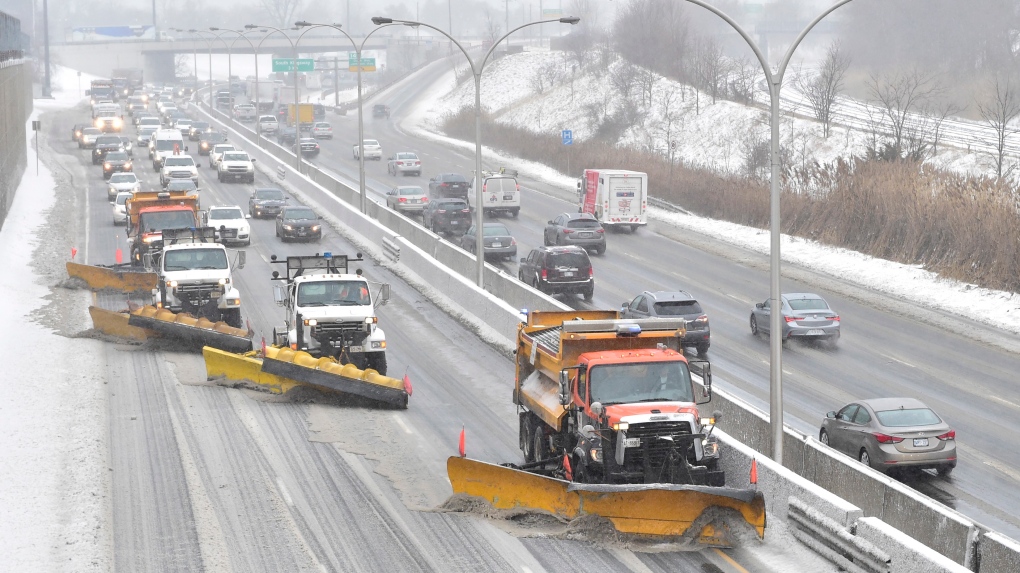
 In this file photo, A line of snow plows clears the Gardiner Expressway in Toronto on Tuesday, Feb.12, 2019 after a winter storm hit the region. THE CANADIAN PRESS/Frank Gunn
The Greater Toronto Area and much of southern Ontario are being hit with a mix of messy winter weather on the heels of a spring-like reprieve.
A snowfall warning is currently in effect from Environment Canada for the City of Toronto and many surrounding areas. The agency also issued a special weather statement due to the rain fall.
According to the agency, the city could see as much as 15 to 25 mm of rain from Wednesday evening through Thursday evening, followed by snowfall accumulation of 10 to 20 cm from Thursday afternoon through Friday morning.
“A low pressure system is expected to track northeast across Lake Erie and Lake Ontario Thursday night which will bring a messy mix of wintry precipitation to southern Ontario,” Environment Canada wrote in its warning.
“Rain is expected to transition to snow this morning or this afternoon.”
Snowfall warnings are also in effect for York, Durham and Peel regions, as well as most areas of southern Ontario from Cornwall to Windsor.
Environment Canada noted that precipitation timing and amounts may change, as the exact track of the system remains uncertain.
“Be prepared to adjust your driving with changing road conditions,” the agency warned. “Rapidly accumulating snow could make travel difficult over some locations. Visibility may be suddenly reduced at times in heavy snow. Surfaces such as highways, roads, walkways and parking lots may become difficult to navigate due to accumulating snow.”
CP24 Meteorologist Chris Potter said commuters should be ready to go from “spring to winter in just a matter of hours tomorrow.”
“Spring-like conditions here at least for now through the overnight and early tomorrow morning, and then winter makes a grand reappearance as we cool down,” Potter said.
He said both morning and evening commutes are likely to be impacted by the messy weather.
“The first one in the morning obviously will be impacted by the potential for ponding, cooling, hydroplaning, slightly reduced visibility and rainfall,” Potter said. “But then by the afternoon and into the evening, icy, slippery roads are expected because obviously we go from warm to cold.
“So any lingering water, standing water might freeze up and then of course the added un-benefit, if you will, of freezing rain and ice pellets across the lower Great Lakes, including the GTA.”
After weeks of frigid temperatures, the city saw an unseasonable high of 9 C Wednesday.
A high of 6 C is expected Thursday morning, but the temperature is expected to drop into the afternoon, going down to a low of -11 C.
In a news release Wednesday, the City of Toronto said “winter crews and equipment are ready to respond” to the messy weather.
“The city has a comprehensive snow and ice response plan with operations focused on the safety and movement of residents and emergency vehicles with the salting and plowing of roads, sidewalks and bike lanes,” the city said in its release.
The city said it would provide an update on its efforts Thursday and advised drivers to use extra caution on the roads.
The City of Toronto also issued a extreme cold weather alert on Thursday morning, saying its warming centres will be open to the public until further notice.
CTVNews.ca Top Stories

BREAKING Real GDP per capita declines for 6th consecutive quarter, household savings rise
Statistics Canada says the economy grew at an annualized pace of one per cent during the third quarter, in line with economists' expectations.
W5 Investigates A 'ticking time bomb': Inside Syria's toughest prison holding accused high-ranking ISIS members
In the last of a three-part investigation, W5's Avery Haines was given rare access to a Syrian prison, where thousands of accused high-ranking ISIS members are being held.
Class-action lawsuit on 'opioid-related wrongs': Court to rule on drug companies' appeal
Canada's top court will rule Friday on the appeal of a class-action lawsuit meant to recoup some of the costs associated with British Columbia's opioid crisis from major drug makers and distributors.
As Australia bans social media for children, Quebec is paying close attention
As Australia moves to ban social media for children under 16, Quebec is debating whether to follow suit.
Irregular sleep patterns may raise risk of heart attack and stroke, study suggests
Sleeping and waking up at different times is associated with an increased risk of heart attack and stroke, even for people who get the recommended amount of sleep, according to new research.
California man who went missing for 25 years found after sister sees his picture in the news
It’s a Thanksgiving miracle for one California family after a man who went missing in 1999 was found 25 years later when his sister saw a photo of him in an online article, authorities said.
Trudeau Liberals' two-month GST holiday bill passes the House, off to the Senate
The federal government's five-page piece of legislation to enact Prime Minister Justin Trudeau's promised two-month tax break on a range of consumer goods over the holidays passed in the House of Commons late Thursday.
Nick Cannon says he's seeking help for narcissistic personality disorder
Nick Cannon has spoken out about his recent diagnosis of narcissistic personality disorder, saying 'I need help.'
Notre Dame Cathedral: Sneak peek ahead of the reopening
After more than five years of frenetic reconstruction work, Notre Dame Cathedral showed its new self to the world Friday, with rebuilt soaring ceilings and creamy good-as-new stonework erasing somber memories of its devastating fire in 2019.


