What to expect as 'significant' snowstorm tracks towards southern Ontario
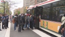
 A man clears his driveway after a snowstorm on Saturday January 15, 2022. THE CANADIAN PRESS/John Morris
A special weather statement has been issued for southern Ontario with a significant snow storm expected to hit this week.
According to the statement issued by Environment Canada, snowfall of 10 to 15 centimetres is possible by late Wednesday evening.
More snow is also expected on Thursday morning.
"Rapidly accumulating snow will make travel difficult," the weather agency said Sunday. "Significant snowfall possible late Wednesday into Thursday."
The agency warned the snowfall amounts may be up to 20 centimetres in certain municipalities. Reduced visibility due to heavy snow is likely.
Environment Canada said the temperature will remain relatively steady throughout the week, despite the precipitation.
Toronto, Markham, Hamilton, Ottawa, Peel, London, Niagara, Peterborough, Waterloo, Windsor, and Durham are some of the regions included in the weather statement.
“There is a low pressure system that looks like it will form in through Texas and track towards Ontario throughout the week,” CTV News Toronto’s Weather Anchor Jessica Smith said.
“It will pick up moisture from the Gulf of Mexico on Tuesday and right now looks like it will impact areas around Windsor in the morning on Wednesday, making its way into the GTA early afternoon and will impact the evening commute.”
"People should plan ahead when it comes to their travel plans, including any possible transit delays due to weather," Smith added.
Toronto Top Stories
-
-
-
-
-
 GARDINER GRIDLOCK
GARDINER GRIDLOCK 'It's just been a nightmare': Gardiner restrictions are Toronto's traffic tipping point
-
-
-

CTVNews.ca Top Stories

A healthy lifestyle can mitigate genetic risk for early death by 62%, study suggests
Even if your genetics put you at greater risk for early death, a healthy lifestyle could help you significantly combat it, according to a new study.
When you have a moment's notice to evacuate, what do you take?
Knowing what to have at home, or take with you for an evacuation, can be useful and even life-saving.
B.C. brings in law on name changes on day that child killer's new identity revealed
The BC NDP have tabled legislation aimed at stopping people who have committed certain heinous acts from changing their names.
Ellen DeGeneres addresses the 'hurtful' end of her talk show in new stand-up set
Ellen DeGeneres is reflecting on how her talk show came to an end in her newest Netflix special, 'Ellen's Last Stand ... Up Tour.'
Avs forward Valeri Nichushkin suspended at least six months
Colorado Avalanche forward Valeri Nichushkin was suspended for at least six months without pay and placed in Stage 3 of the league's player assistance program.
Western University researchers unlock potential 'cure' for ALS
New research out of London, Ont.'s Western University is shedding light on a potential cure for ALS, in which the targeting of the interaction between two proteins can halt or fully reverse the disease's progression.
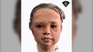
Police release 3D images of young child found in an Ontario river two years ago
Police have released a three-dimensional image of a young child whose remains were discovered in the Grand River in Dunnville, Ont. almost two years ago.
B.C. man fighting for refund after finding someone living at Whistler vacation rental
Edwin Mostered spent thousands of dollars booking a vacation home in Whistler, B.C., for a group skiing trip earlier this year – or so he thought.
Kamala Harris drops F-bomb during White House live-stream
U.S. Vice-President Kamala Harris used a profanity on Monday while offering advice to young Asian Americans, Native Hawaiians and Pacific Islanders about how to break through barriers.
Shopping Trends
The Shopping Trends team is independent of the journalists at CTV News. We may earn a commission when you use our links to shop. Read about us.


Montreal
-

Montreal businesses apologize after video shows man throw water on sleeping homeless person
Two Montreal businesses are apologizing after a video circulating on social media showed a man throwing water on a homeless person sleeping outside of a Chinatown storefront.
-
McGill University encampment: judge expected to deliver injunction decision Tuesday
Pro-Palestinian protesters at McGill University have become 'occupiers' living in a fortified and barricaded mini-village, a lawyer for the Montreal school argued on Monday as he asked for an injunction to dismantle the more than two-week-old encampment on its downtown campus.
-
Pro-Palestinian camp set up at Universite de Sherbrooke
Following in the footsteps of McGill University and UQAM, students at Universite de Sherbrooke have set up a camp on their school grounds to protest the war between Israel and Hamas.
Ottawa
-
 NEW THIS MORNING
NEW THIS MORNING Israeli flag-raising ceremony in Ottawa will be private affair
The Israeli flag is flying at Ottawa City Hall today to mark the country's national day, with plans to hold a private ceremony to mark Israel's Independence Day. There is a significant police presence at City Hall, including security barriers outside the main doors.
-
Murder charge laid in Donald Street apartment fire after 1 victim dies
Ottawa police have upgraded an attempted murder charge against a 42-year-old man after one of the victims of an apartment fire earlier this month died.
-
OPP investigating collision involving school bus and child in Rockland, Ont.
Ontario Provincial Police are investigating a collision in Rockland Monday afternoon involving a school bus and a child.
Northern Ontario
-

Timmins man in Highway 144 crash was impaired, had two kids in car, police say
A 29-year-old Timmins man is charged with impaired driving in a single-vehicle crash on Highway 144 near Greater Sudbury that sent two children to hospital by air ambulance Saturday.
-
Vehicle rollover in northern Ont. leads to impaired charges
A vehicle travelling on Highway 11 early in the morning last weekend rolled over in the ditch just west of Smooth Rock Falls.
-
Southern Ont. man charged with attempted murder in Timmins shooting
One of two men wanted for attempted murder in Timmins has been arrested, while a warrant has been issued for a second suspect, who fled police on foot.
Kitchener
-
Kitchener city council votes to give THEMUSEUM $300K to stay open
Kitchener city councillors voted in favour of giving THEMUSEUM $300,000 to avoid being forced to close.
-
OPP share 3D face recreation to help identify baby found in Grand River
A $50,000 reward is being provided by the Government of Ontario to help identify a young child whose remains were found along the Grand River in 2022.
-
Toonie sized hail and heavy rain expected in northern Wellington County : Environment Canada
People living in Wellington County North, Arthur and Mount Forest are being advised to take cover as scattered thunderstorms sweep across the area into Monday evening.
London
-

Councillors pull no punches during discussion about their salaries and workload
Councillors offered an unvarnished glimpse into what it’s like to represent their constituents at city hall during a meeting of the Governance Working Group (GWG). The deputy mayor said rather than part-time or full-time his job is 'all the time.'
-
PLAYOFF TRACKER
PLAYOFF TRACKER London Knights lead OHL Finals 3-0 after forcing overtime in Oshawa
Compared to their first two games on home ice, it was a close call for the London Knights in Oshawa Monday night.
-
Western University researchers unlock potential 'cure' for ALS
New research out of London, Ont.'s Western University is shedding light on a potential cure for ALS, in which the targeting of the interaction between two proteins can halt or fully reverse the disease's progression.
Windsor
-
Unanimous support for downtown Windsor by council
After a marathon, six-hour meeting on the Downtown Windsor Revitalization Plan, council and the mayor voted in favour of increasing taxes to support the core.
-
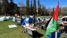
Liberation Zone ready for extended stay at UWindsor
A Pro-Palestinian supporter is in for the long haul at the University of Windsor’s Liberation Zone. 'I'm here for as long as it takes,' the supporter said.
-
'I was just stunned': Seeing the northern lights was a bucket list sighting for people in Windsor-Essex
As a fan of all things astronomy, Zeel Parmar has long dreamt of flying to Alaska to witness the northern lights with her own eyes — so she was shocked to find the colours of the aurora borealis shimmering over the skies of Windsor, Ont. late Friday night.
Barrie
-

New facility aims to make Muskoka housing more affordable
A new facility officially unveiled in Gravenhurst aims to significantly reduce the ongoing housing affordability crisis.
-
Mother of 2 killed in Innisfil crash
Young mother was killed in a two-vehicle crash in Innisfil Saturday morning.
-
Barrie boy arrested after alleged assault leaves female victim hospitalized
A Barrie teen faces serious charges after an alleged altercation in a parking lot that police say sent a female to the hospital.
Winnipeg
-
Security video caught admitted serial killer disposing of bodies in Winnipeg garbage bins
Security video caught admitted serial killer Jeremy Skibicki on multiple late-night outings, disposing of body parts in nearby garbage bins and dumpsters in the middle of the night.
-
'Never seen a fire move like this': Dry conditions cause significant spread of Manitoba wildfire
Fire crews are continuing to battle a significant blaze in Manitoba’s north that has prompted evacuations.
-
Man drowns in Whiteshell Provincial Park after canoe capsizes: RCMP
A Winnipeg man has died after his canoe tipped over on Sunday.
Atlantic
-

Arthur Irving, former president of Irving Oil, dead at 93
Arthur L. Irving, chairman emeritus and former president of Irving Oil, has died at the age of 93.
-
Famous girl group TLC cancels Moncton show after tour members, including lead singer, fall ill
TLC fans looking forward to their concert in Moncton, N.B., on Tuesday will be disappointed to find out that the show has been cancelled due to illness.
-
Woman charged with stunting after speed clocked at more than 50 km/h over the limit: Halifax police
A 26-year-old woman has been charged with stunting after allegedly driving more than 50 km/h over the speed limit in the Halifax-area on Monday.
N.L.
-
'Irate male' assaulted Newfoundland officers with block of cheese, police say
Police in Newfoundland say patrol officers were assaulted Thursday by a "very irate male" wielding a block of cheese.
-
Whooping cough outbreak declared in Newfoundland
Health officials say there is an outbreak of whooping cough in eastern Newfoundland.
-
Trucker's body found in trailer in Newfoundland after failed police search in Ontario
Ontario Provincial Police are facing tough questions about their search for a missing Newfoundland trucker whose rig was found two weeks ago in Ontario, then sent back to Newfoundland, where his body was found Monday in the trailer.
Edmonton
-
Alberta to investigate police crackdown on pro-Palestinian campus protests
Alberta Premier Danielle Smith says her government will ask the province’s police watchdog to investigate how officers forcibly cleared out two pro-Palestinian protests on university campuses.
-
Calls for more spending on Alberta health care following senior's 3-week stay in hospital hallway
A woman whose 81-year-old father recently spent three weeks receiving care in an Edmonton hospital hallway is joining the Alberta NDP to call for better care, including more health-care workers, and a south Edmonton hospital.
-
Skinner under scrutiny as Oilers search for spark against Canucks
Stuart Skinner, the Oilers' starting goalie all season and for each of their eight post-season games this year, allowed all four goals scored against his team Sunday night, some of them arguably his fault.
Calgary
-
Alberta to investigate police crackdown on pro-Palestinian campus protests
Alberta Premier Danielle Smith says her government will ask the province’s police watchdog to investigate how officers forcibly cleared out two pro-Palestinian protests on university campuses.
-
Teen stabbed behind northwest Calgary high school, rushed to hospital with serious arm injury
A teenage boy was stabbed late Monday afternoon near John G. Diefenbaker High School in Calgary's northwest.
-
'We're expecting that this season will be pretty bad': Smoky summer on the horizon
It's hazy, it smells and it's a sign that another Alberta summer is on the horizon.
Regina
-

Saskatchewan Party MLAs barred from Regina Pride parade over school pronoun law
Organizers for Regina's Pride parade have barred legislature members of the governing Saskatchewan Party from participating in the event in June.
-
Regina police investigating fatal collision on 7th Avenue
The Regina Police Service (RPS) is asking drivers and pedestrians to avoid 7th Avenue between Retallack Street and Cameron Street as an investigation is underway.
-
'I was in shock': Sask. homeowner finds a porcupine stowaway in her garage
In a growing city it’s no surprise when suburban residents come across wild animals around their yards, but one Saskatoon homeowner in Kensington started poking around for answers when she spotted a quilled critter hanging out in her garage.
Saskatoon
-

'I was in shock': Sask. homeowner finds a porcupine stowaway in her garage
In a growing city it’s no surprise when suburban residents come across wild animals around their yards, but one Saskatoon homeowner in Kensington started poking around for answers when she spotted a quilled critter hanging out in her garage.
-
Looming fall election puts pressure on province to end dispute with teachers, professor says
The end of the school year and a looming fall election are putting additional pressure on the province to strike a deal with Saskatchewan teachers, according to two political scientists.
-
The driver of a dump truck in a serious crash on Circle Drive has died, police say
Saskatoon police say the driver of a dump truck heavily damaged in a crash on Circle Drive on Friday died in hospital.
Vancouver
-

'We'll look after you': Locals feeding, housing Fort Nelson evacuees
With thousands evacuating Fort Nelson due to a wildfire encroaching on the town, nearby communities are opening their doors to those who’ve had their lives turned upside down in a matter of moments.
-
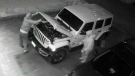
Thieves caught on camera stealing pet chicken from North Vancouver backyard
A $200 reward is being offered by a North Vancouver family for the safe return of their beloved chicken, Snowflake.
-
B.C. brings in law on name changes on day that child killer's new identity revealed
The BC NDP have tabled legislation aimed at stopping people who have committed certain heinous acts from changing their names.
Vancouver Island
-
B.C. brings in law on name changes on day that child killer's new identity revealed
The BC NDP have tabled legislation aimed at stopping people who have committed certain heinous acts from changing their names.
-
Open burning bans coming to coastal B.C. as wildfire activity increases
Most open burning will be banned in coastal B.C. ahead of the May long weekend.
-
Next 48 hours will be 'extremely challenging' for B.C. wildfire crews near Fort Nelson: officials
A wildfire burning dangerously close to Fort Nelson, B.C., has grown to more than 50 square kilometres, and officials are warning that the blaze's behaviour is expected to become more volatile over the next 48 hours.


