'Torrential downpours:' Toronto under rainfall warning due to Hurricane Beryl remnants
A rainfall warning has now been issued for the City of Toronto, with the remnants of Hurricane Beryl expected to result in torrential downpours overnight and into tomorrow.
Environment Canada issued the warning on Tuesday afternoon. It replaces a special weather statement that was previously in effect.
The weather agency says that there could be rainfall totals of 40 to 60 millimetres across most of southern Ontario as a result of the storm, with higher amounts possible in some areas.
"Periods of heavy rainfall associated with the remnants of Hurricane Beryl will affect portions of southern Ontario beginning overnight or Wednesday morning. These types of weather systems can give very high rainfall rates in torrential downpours," the warning states.
"Rainfall amounts will likely be highly variable across the region, and some areas may receive in excess of 60 mm."
Beryl made landfall in Texas as a Category 1 hurricane on Monday after leaving a path of destruction in the Caribbean over the weekend.
The storm has weakened significantly since making landfall but could still bring torrential rain to most of Ontario.
The rain is forecast to begin at around 1 a.m. with some of the heaviest bands possible during the morning rush hour on Wednesday.
“It looks like the heaviest rain will be in the Lake Huron area and Eastern Ontario but we could pick up 20 to 40 mm of rain in a very short period of time (in the GTA) and that will cause some localized ponding and flooding,” CP24 Meteorologist Bill Coulter warned earlier on Tuesday morning.
“So be aware of that tomorrow morning and maybe give yourself some extra time. By the time Thursday is done the whole system and the cloud goes with it, setting up a really nice weekend. The challenge will just be dealing with it, mostly tomorrow morning.”
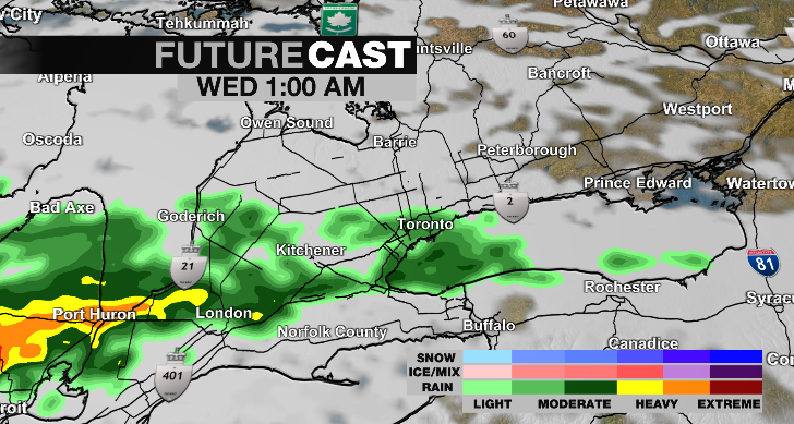 The remnants of Hurricane Beryl are shown arriving in the GTA on Future Cast radar. (CP24)
The Toronto and Region Conservation Authority has issued a flood watch ahead of the arrival of the system and is warning that “all shorelines, rivers and streams within the GTA should be considered dangerous.”
The authority has said that due to the rainfall totals there is also “potential for widespread flooding” within its jurisdiction on both Wednesday and Thursday.
“Ground conditions are not saturated, however, will likely become saturated throughout the TRCA jurisdiction after tomorrow (Wednesday) morning’s rainfall event. As such, all watercourses and water levels within TRCA watersheds are expected to rise beginning early tomorrow (Wednesday) morning into Thursday due to the forecasted rainfall,” the flood watch states.
In its warning Environment Canada said that the heaviest bands of rain could total between 20 and 40 millimetres per hour.
The storm, however, will not carry significant winds.
The weather agency says that winds will only reach about 20 km/h overnight and 30 km/h on Wednesday
“As it gets caught up in the jet stream it loses some of its tropical characteristics, the circular shape, and it is being more stretched out as it flows up the Ohio River Valley and right into the lower Great Lakes region,” Coulter said. “It will arrive around 1 a.m. overnight and because it has been stretched out there is quite a long period of some heavy rain. Most of that will come after midnight tonight, through the morning rush and into mid-day.”


CTVNews.ca Top Stories

BREAKING
BREAKING Sport court dismisses Canada's appeal in women's soccer case
The Court of Arbitration for Sport has dismissed Canada's appeal of a six-point penalty against its Olympic women's soccer team.
Man linked to four murders in Kirkland Lake, Ont., is dead, police say
Ontario Provincial Police say Martyn Rosko, the main suspect in four homicides in Kirkland Lake, is dead.
Want to move out of Canada? Experts explain everything you need to know
If you're planning to leave Canada, there's a laundry list of things that need to be checked off. Experts explain all the steps you need to take before making the move.
Colombian President Petro calls on Venezuela's Maduro to release detailed vote counts from election
Colombian President Gustavo Petro on Wednesday called on his close ally, Venezuelan President Nicolas Maduro, to release detailed vote counts of the weekend election in which electoral authorities declared Maduro the winner.
Starbucks sales tumble as customers reject high-priced coffee
Fewer people are going to Starbucks and buying drinks and food, as last quarter was Starbucks' second straight with a sales decline.
Vermont man evacuates neighbours during flooding, weeks after witnessing a driver get swept away
Weeks after Jason Pilbin witnessed a driver get swept away by floodwaters, his northeastern Vermont community was ravaged again by flooding from heavy rains.
Families seek answers after inmates' bodies returned without internal organs
Six families whose loved ones died in Alabama prisons have filed lawsuits against the commissioner of the state's department of corrections, saying their family members' bodies were returned to them missing internal organs after undergoing state-ordered autopsies.
Economy grew 0.2% in May, StatCan estimates 2.2% annualized growth in Q2
The Canadian economy continued to keep its head just above water in May, growing 0.2 per cent, led by expansions in manufacturing and the public sector.
'Severely hypothermic' sailor rescued after spending hours adrift off B.C. coast
A sailboat captain was found alive but suffering from a severe case of hypothermia on Monday after spending up to five hours adrift in the ocean off British Columbia, according to the coast guard.
Shopping Trends
The Shopping Trends team is independent of the journalists at CTV News. We may earn a commission when you use our links to shop. Read about us.


Montreal
-

Quebec woman who allegedly posed as lawyer arrested after missing court
A Quebec woman who allegedly pretended to be a lawyer and evaded the authorities for weeks has been arrested.
-
10-year-old boy missing in Montreal
Montreal police is looking for 10-year-old Jordan Blessing Nkhingu.
-
Quebec e-bus and truck company Lion Electric cuts its workforce again, this time by 30 per cent
For the third time this year, Quebec manufacturer of electric medium- and heavy-duty urban vehicles, Lion Electric, is slashing its workforce, reducing its workforce by 30 per cent.
Ottawa
-

Pedestrian dies after being struck by a vehicle in Ottawa's south end
Emergency crews responded to a collision involving a pedestrian on Albion Road, between Rideau Road and Mitch Owens Road, just before midnight.
-
Ottawa sees rise in whooping cough cases
Ottawa Public Health is reminding parents to add vaccinations to the back-to-school list for the fall, as the capital sees an increase in whooping cough cases.
-
BREAKING
BREAKING Sport court dismisses Canada's appeal in women's soccer case
The Court of Arbitration for Sport has dismissed Canada's appeal of a six-point penalty against its Olympic women's soccer team.
Northern Ontario
-
 BREAKING
BREAKING Sudbury police investigating death at Bell Park
Sudbury police say they are investigating a death at Bell Park and are asking the public to avoid it.
-
Serious crash closes road at busy downtown Sudbury intersection
Police are asking people to avoid the Lloyd Street area after a serious crash at a busy downtown Sudbury intersection Wednesday morning.
-
Man linked to four murders in Kirkland Lake, Ont., is dead, police say
Ontario Provincial Police say Martyn Rosko, the main suspect in four homicides in Kirkland Lake, is dead.
Kitchener
-

Death of neighbourhood deer sparks anger among Waterloo residents
Waterloo residents are frustrated over the death of a wild deer that had been living in their neighbourhood, after repeated requests to help the animal were ignored.
-
Guelph mayor calls out public drug use in city
The Mayor of Guelph is speaking out about drug use in public spaces.
-
Free little library destroyed in Kitchener
Damaged books and bits of wood littered the ground on Wednesday after a free little library in Kitchener was destroyed.
London
-

Back to work at IMT Defence in Ingersoll
Workers voted to ratify a new four-year collective agreement that eliminates the two-tier wage system, they said discriminated against new hires and existing workers with limited seniority.
-
Cyclist killed after being struck by transport truck
One person has died after a crash Monday night in Lambton County. Around 10:05 p.m., crews responded to the area of London Line and Telfer road for the crash involving a transport truck and a cyclist.
-
Intersection reopens following crash involving propane tanker truck
Just after 12 p.m. on Tuesday, emergency crews rushed to the scene in Thames Centre after a transport carrying a full load of propane, collided with an SUV.
Windsor
-

Heat warning issued for Windsor-Essex
Environment Canada has issued a heat warning for Windsor-Essex. High temperatures are expected to continue through Thursday.
-
BREAKING
BREAKING Sport court dismisses Canada's appeal in women's soccer case
The Court of Arbitration for Sport has dismissed Canada's appeal of a six-point penalty against its Olympic women's soccer team.
-
Here’s when you can expect a settlement payment from Loblaw for admitting to bread price fixing
A Windsor law firm has been working on the case since it first came to light nearly a decade ago.
Barrie
-
Swim advisory for Couchiching Beach
Couchiching Beach in Orillia has a swim advisory in place.
-
Wasaga Beach calls for tent ban on beach
Following reports of people defecating on the beach, Wasaga Beach Mayor Brian Smith passed a motion in council on Monday, formally requesting the province to ban four-sided tents on the beach.
-
Rehabilitation centre for wildlife nears completion
The National Wildlife Centre in Caledon Ont., has been helping sick and injured wildlife for 10 years and will soon offer its first permanent wildlife field hospital.
Winnipeg
-

Bees, wasps to blame for wading pool closure
There’s a buzz at the Braeside Park wading pool and it’s not the sound of kids splashing around.
-
Remains believed to be missing man found in wooded area: Manitoba RCMP
The remains of a missing Manitoba man were found in a wooded area on Monday.
-
Rally for better bike safety blocks Winnipeg intersection
Protestors shut down the Maryland Bridge on Tuesday as they called for better bike safety.
Atlantic
-

Average Canadian household spends almost half its income on taxes: Fraser Institute
Taxes are the largest household expense for families in Canada.
-
BREAKING
BREAKING Sport court dismisses Canada's appeal in women's soccer case
The Court of Arbitration for Sport has dismissed Canada's appeal of a six-point penalty against its Olympic women's soccer team.
-
Sand from the Sahara Desert causing recent lull in the hurricane season: scientists
Tiny grains of sand from the Sahara Desert are to blame for the almost month-long lull in this year's Atlantic hurricane season, scientists say. But it could soon come to an end.
N.L.
-

N.L. university chair disciplined for sending pro-Palestinian email to alumnus's dad
The chair of the board of regents at Memorial University in Newfoundland and Labrador has been asked to take privacy training after he forwarded an alumnus's pro-Palestinian campaign email to her father.
-
After a harrowing rescue in the cold Atlantic, a fisherman wanted two things: A new guitar, and Nickelback tickets
Newfoundland and Labrador Premier Andrew Furey gave a special gift to David Tiller, one of seven fishermen who survived 48 hours on a life raft in the Atlantic Ocean.
-
Newfoundland and Labrador doubles funeral benefits after unclaimed bodies pile up
The Newfoundland and Labrador government has more than doubled the financial assistance it offers low-income residents who need to pay for a burial or a cremation, as health officials scramble to deal with unclaimed bodies at the province's largest hospital.
Edmonton
-

Jasper's fire-affected small businesses face rocky road ahead
After labouring for months to bring one of Jasper's newest business concepts to life, the owners of The Peacock Cork & Fork never dreamed the young restaurant's run would be so short-lived.
-
WEATHER
WEATHER Josh Classen's forecast: Warm with a late-day storm risk
We should see afternoon highs in the mid to upper 20s through the rest of the week and the coming weekend in Edmonton.
-
Edmonton man sentenced to 5 years in prison in terrorism case in United Kingdom
An Edmonton man has been sentenced to five years in prison after being convicted in the United Kingdom of being a member of a proscribed terrorist group.
Calgary
-

Alberta Day of Caring: Recycle empty bottles and cans to help Jasper wildfire evacuees
It's the Alberta Day of Caring, a province-wide event to support Jasper wildfire evacuees.
-
Murder-conspiracy trial tied to Coutts, Alta., COVID-19 blockade set to go to jury
A jury is set to begin deliberating today the fate of two men accused of conspiring to kill police at the Coutts, Alta., blockade in 2022.
-
Jasper's fire-affected small businesses face rocky road ahead
After labouring for months to bring one of Jasper's newest business concepts to life, the owners of The Peacock Cork & Fork never dreamed the young restaurant's run would be so short-lived.
Regina
-

Sask. currently dealing with over 80 wildfires, none threatening communities, SPSA says
As the devastating wildfire in Jasper National Park continues to burn, Saskatchewan is currently batting more than 80 active wildfires of its own. However, none are currently encroaching on any communities, the Saskatchewan Public Safety Agency said on Tuesday.
-
Former Sask. MLA Lyle Stewart dead at 73
Former Saskatchewan Party MLA and provincial cabinet minister Lyle Stewart has died following a lengthy battle with cancer.
-
'It was a shock': Fire claims historic hotel and café in Radville, Sask.
A long standing fixture in Radville, Sask. was destroyed by a fire in the early hours of Monday morning.
Saskatoon
-

Pierre Poilievre spouts 'uneducated' opinions on safe consumption sites: Prairie Harm Reduction
The executive director of a Saskatoon-based harm reduction group says federal Conservative leader Pierre Poilievre’s statements on supervised consumption sites are “uneducated.”
-
Potentially toxic algae discovered in Saskatoon pond
The City of Saskatoon has issued a warning to residents about the presence of toxic cyanobacteria in Briarwood Pond.
-
Former Sask. MLA Lyle Stewart dead at 73
Former Saskatchewan Party MLA and provincial cabinet minister Lyle Stewart has died following a lengthy battle with cancer.
Vancouver
-

'I absolutely felt threatened': Former VPD exec speaks out alleging workplace toxicity and complicity
She spent nearly 20 years working for the Vancouver Police Department, and now the woman at the centre of a lawsuit is speaking publicly about the threatening environment she claims to have experienced, and the alleged inaction of management.
-
West Vancouver mayor on deadline to enact new housing bylaws: 'The gun is to our head'
Last Thursday, Housing Minister Ravi Kahlon gave West Vancouver's mayor and council 30 days to change the city's bylaws to comply with new provincial regulations allowing for the construction of multiple units on all single family lots.
-
New poll shows BC Conservatives closing gap with NDP as BC United loses another MLA
A poll released Tuesday shows the gap narrowing between the BC NDP and the BC Conservatives with the latter party trailing by just three points months before the provincial election.
Vancouver Island
-

Wildfire burning near Sooke, B.C., now being held
A wildfire burning west of Victoria is no longer considered out of control, according to an update from the B.C. Wildfire Service Tuesday.
-
New poll shows BC Conservatives closing gap with NDP as BC United loses another MLA
A poll released Tuesday shows the gap narrowing between the BC NDP and the BC Conservatives with the latter party trailing by just three points months before the provincial election.
-
'Severely hypothermic' sailor rescued after spending hours adrift off B.C. coast
A sailboat captain was found alive but suffering from a severe case of hypothermia on Monday after spending up to five hours adrift in the ocean off British Columbia, according to the coast guard.


