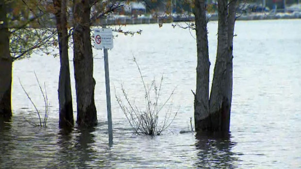
Areas across the Toronto Islands faced substantial flooding on Thursday night due to high winds and rising water levels in Lake Ontario.
Brad Ross, a spokesperson for the City of Toronto, said at around 5 p.m., waves in the harbour breached sandbags on the north shore of the islands, resulting in “significant flooding” near some homes.
Ward’s Island, he said, was hit with the worst of the flooding.
“There are some homes that are surrounded by anywhere from five to 20 centimetres of water depending on where the home is. The far eastern portion of Ward’s Islands is relatively dry,” Ross said in an interview with CP24 on Thursday night.
“Residents who live on the island who took precautions around their own property… are probably OK.”
Ross said on some parts of the island, the roadways are submerged in about 30 to 40 centimetres of water.
“Overall it is something that is going to take at least 72 hours to clean up. We’ve got pumps in place to get that water out of there. We will be re-sandbagging areas that were breached tomorrow,” he said.
Non-essential vehicles from the mainland will not be allowed onto the islands for the next 72 hours, Ross noted.
Centre Island has remained relatively unscathed from the flooding.
“Centre Island is relatively high so it is dry. The park is accessible,” Ross said, adding that the islands are safe and open to the public.
He said there is “absolutely no need” for any kind of evacuations at this point.
Spring flooding in 2017 resulted in the erosion of parts of the beach shoreline as well as a three-month closure of Centreville. At its highest point, the water levels were recorded at 75.93 meters.
Last week, the Toronto Regional Conservation Authority issued a shoreline hazard warning, saying said that the water level was sitting at 75.74 meters.
“With continued recording breaking inflows from Lake Erie as well as received rainfall and reduced outflows due to ongoing flood risk in the Lower St. Lawrence River, water levels in Lake Ontario will continue to rise in the coming weeks,” the agency said in the warning issued on May 16. “Please exercise caution around all Lake Ontario shoreline areas, and avoid areas that are flooded or are experiencing erosion. Boardwalks and other trails along Lake Ontario can be dangerous during times of high waves.”
According to Environment Canada, Toronto is expected to be hit with rainfall throughout the weekend. On Thursday, the weather agency called for a 60 per cent chance of rainfall along with a risk of thunderstorms. There is a 60 per cent chance of showers on Saturday, Environment Canada said.
“This Saturday we are expecting a weather event and rain and possible thunderstorms,” Ross said. “Depending on the direction of that storm, it may impact our efforts to mitigate flooding.”
Winds have caused high waves in the harbour, breaching sandbagging efforts on the north shore of Toronto island. As a result, significant flooding is occurring near homes. Staff are on site now assessing damage and will begin restoring barriers and pumping water. More to follow.
— Brad Ross (@bradrossTO) May 23, 2019


