'It could be the last real blast of winter:' Rain may change into snow tonight as temperatures drop in Toronto
A spring storm brought heavy rain, strong winds and wet snow to the Greater Toronto Area Wednesday evening, causing power outages.
As of 11 p.m., about 8,000 Hydro One customers in Bowmanville were left in the dark due to a power outage. On its website, the company said crews were responding to outages caused by high winds.
It was unclear when power would return to the affected customers.
- Download our app to get local alerts on your device
- Get the latest local updates right to your inbox
Rain was expected to transition to wet snow Wednesday night, especially for areas away from Lake Ontario, as temperatures dropped to 2 C from a high of 6 C earlier in the day. However, Environment Canada said snowfall amounts won’t be significant.
Toronto could expect about two centimetres of snow locally.
While the rain has been manageable, the temperature drop and snowfall could lead to issues with traffic, University of Waterloo Meteorologist Frank Seglenieks told CP24 on Wednesday afternoon.
“Most of the problems associated with it are going to be from the wet heavy snow falling later on today and into tomorrow,” he said. “That's just going to cause a lot of chaos as far as traffic goes.”
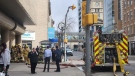
Winds, which gusted up to 80 kilometres an hour earlier in the day, were expected to ease by Wednesday evening. Several Toronto hospitals under the University Health Network faced a system outage Wednesday morning due to the weather and strong winds.
While the winds will die down, Seglenieks noted that much of the weather problems in the region will be instead due to the wet snow and rain over the next 24 hours.
The Toronto Police Service warned residents to stay away from rivers, streams and shorelines, which are at risk of flooding.
There is a 40 per cent chance of flurries and rain showers Thursday morning and temperatures are expected to hit around 3 C.
The precipitation is forecast to continue until the weekend, with the sun finally peeking out on Saturday. Temperatures are expected to hit the double digits at this point.
Seglenieks noted that this may the last blast of wintery weather in the region.
“Certainly winter storms and snow accumulation can still happen in April and even into late April so we're not past that hump yet,” he said.
“But it could be the last real blast of winter that we'll see this year … for the next couple of weeks it looks like it is going to be getting more towards the spring side of the temperatures.”


CTVNews.ca Top Stories

Freeland tables motion previewing omnibus budget bill
Deputy Prime Minister and Finance Minister Chrystia Freeland will be tabling yet another omnibus bill to pass the sweeping range of measures promised in her April 16 federal budget.
Man dies after suffering cardiac arrest while waiting in ER, widow wants investigation
When an ambulance took David Lippert to the hospital in March of 2023, the 68-year-old Kitchener, Ont., executive was hoping to find out why he was feeling weak and unable to walk. Some 24 hours later, he was found unresponsive in the ER.
BREAKING
BREAKING Baby, grandparents among 4 people killed in wrong-way police chase on Ontario's Hwy. 401
A police chase which started with a liquor store robbery in Bowmanville Monday night ended in tragedy some 20 minutes later when a suspect fleeing police entered Highway 401 in the wrong direction and caused a pileup which killed an infant and the child's grandparents, as well as the suspect, investigators say.
Air Canada walks back new seat selection policy change after backlash
Air Canada has paused a new seat selection fee for travellers booked on the lowest fares just days after implementing it.
McGill requests 'police assistance' over pro-Palestinian encampment
McGill University says it has 'requested police assistance' about the pro-Palestinian encampment on its lower field.
Judge raises threat of jail in hush money trial as he holds Trump in contempt, fines him US$9,000
Donald Trump was held in contempt of court Tuesday and fined US$9,000 for repeatedly violating a gag order that barred him from making public statements about witnesses, jurors and some others connected to his New York hush money case. And if he does it again, the judge warned, he could be jailed.
Court upholds Milwaukee police officer's firing for posting racist memes after Sterling Brown arrest
The Wisconsin Supreme Court ruled Tuesday that a former Milwaukee police officer was properly fired for posting racist memes related to the arrest of an NBA player that triggered a public outcry.
Video captures deadly wrong-way police chase on Highway 401 in Ontario
A new video has surfaced showing a vehicle being pursued by police in the wrong direction on Highway 401 moments prior to a fatal crash that killed four people, including an infant and their grandparents.
New cancer treatment approved, but not everyone thinks it's what's best for patients
A new cancer treatment recently approved in Canada promises to cut treatment time down to just minutes, but experts have differing opinions on whether it's what's best for patients.
Shopping Trends
The Shopping Trends team is independent of the journalists at CTV News. We may earn a commission when you use our links to shop. Read about us.


Montreal
-

McGill requests 'police assistance' over pro-Palestinian encampment
McGill University says it has 'requested police assistance' about the pro-Palestinian encampment on its lower field.
-
Transit fees are going up in the Montreal area. Here's the new price structure
Transit riders, take note: the Montreal-area regional transit authority, the ARTM, is changing its fare structure on July 1. Prices are going up by an average of 3 per cent.
-
Montreal set to unveil plan for deer overpopulation in east end
The City of Montreal is set to unveil its plan to deal with the overpopulation of white-tailed deer in the island's east end.
Ottawa
-

Costs associated with youth eating disorders reached $39.5 million during COVID pandemic, study suggests
Researchers at Ottawa's CHEO Research Lab are calling for a national surveillance strategy on eating disorders in Canada, as new statistics show a rise in the social and economic costs associated with the issue in children and youth.
-
BREAKING
BREAKING Baby, grandparents among 4 people killed in wrong-way police chase on Ontario's Hwy. 401
A police chase which started with a liquor store robbery in Bowmanville Monday night ended in tragedy some 20 minutes later when a suspect fleeing police entered Highway 401 in the wrong direction and caused a pileup which killed an infant and the child's grandparents, as well as the suspect, investigators say.
-
Quebec man facing charges in two grandparent scams in Cornwall, Ont., police say
A Quebec resident is facing charges in connection to two alleged grandparent scams in Cornwall, Ont. over the past two months.
Northern Ontario
-

Sudbury assault victim struck, tied to a chair and robbed, police say
Sudbury police say they are investigating after a man was allegedly assaulted at a home on Lourdes Street early Tuesday morning.
-
BREAKING
BREAKING Baby, grandparents among 4 people killed in wrong-way police chase on Ontario's Hwy. 401
A police chase which started with a liquor store robbery in Bowmanville Monday night ended in tragedy some 20 minutes later when a suspect fleeing police entered Highway 401 in the wrong direction and caused a pileup which killed an infant and the child's grandparents, as well as the suspect, investigators say.
-
New cancer treatment approved, but not everyone thinks it's what's best for patients
A new cancer treatment recently approved in Canada promises to cut treatment time down to just minutes, but experts have differing opinions on whether it's what's best for patients.
Kitchener
-

Conestoga is a foreign student mecca. Is its climb to riches leading it off a cliff?
Aggressive international recruitment has brought in a flood of new money, but questions are also being raised within the institution about the sustainability of that growth, and the motivations behind it.
-
Guelph, Ont. senior loses $34,000 to benefits scam
A Guelph, Ont. woman in her late 60s has lost $34,000 after falling victim to a Facebook scam.
-
Waterloo exploring potential MZO for new affordable housing project
The City of Waterloo is moving forward with a plan to try and rezone 25 acres of city-owned land near RIM Park to allow for affordable and attainable housing.
London
-

'There are going to be some real issues in terms of enforcement': Parents weigh in on school cellphone ban
The debate around the Ford government cellphone ban in schools continues to stir. Parents and professional educators are weighing in with potential pros and pitfalls.
-
Homeowner finds woman sleeping in their northeast London home
London police have charged a woman after they say a person found a stranger sleeping in their home.
-
London police lay charges after finding bb-style pellet gun
A London woman has been arrested after police were called by somebody who was woken up around 11 p.m. at a city hotel. According to the person who called 911, a woman was seen banging on doors of the hotel while allegedly holding a gun.
Windsor
-

Windsor police issue arrest warrant in relation to March incident
Windsor police have identified and issued an arrest warrant for a person wanted in relation to an attempted break and enter in March. On March 25, at 5:30 a.m., police said a man made several attempts to gain entry into a business in the 1300 block of Provincial Road.
-
Belle River resident one of 12 people arrested by Toronto police in $4M fake ID scheme
‘Project Déjà Vu’ was launched in October 2022 after a financial institution reported fake accounts created by a former employee. Toronto Police describe the crimes as “synthetic-identity credit fraud scheme.”
-
Sinkhole keeps downtown intersection closed until Wednesday evening
The intersection of University Avenue west and Church Street as well as a one-block radius in each direction will remain closed until at least 5 p.m. on Wednesday.
Barrie
-
Suspect accused of making threats and refusing to leave a home
Police responded to a call on Monday night after receiving reports of an individual allegedly making threats and refusing to leave a home.
-
Barrie transit set to roll out new network plan
Barrie Transit is set to roll out the first phase of its new network plan.
-
Police seek help in determining how a young man died in Blue Mountains crash
OPP is investigating a single vehicle crash in the Blue Mountains that claimed the life of one person.
Winnipeg
-

Lawyers for Winnipeg man accused of killing four women continue bid to have jury tossed
The lawyers of an alleged serial killer in Winnipeg are questioning whether pre-trial publicity in the high-profile case may have influenced the jury’s decision-making ability, after a public poll commissioned by the defence found 81 per cent of respondents believe the accused is guilty.
-
What is Road Soup? Winnipeg test drives new pothole patching project
There may be hope for Winnipeggers as they try to dodge numerous potholes on their daily commute. The city is testing out a new product known as Road Soup, which would be used to help fill the craters during the early spring.
-
Nature Playground at Assiniboine Park temporarily closed this spring
If you’re thinking about heading out to the Nature Playground at Assiniboine Park this spring for some family-friendly fun - you’re out of luck. The playground is temporarily closed until mid-June for improvements.
Atlantic
-

Police searching for 'armed man' in Dartmouth, N.S., residents asked to shelter in place
Residents in the area of Gaston Road in Dartmouth, N.S., are being asked to shelter in place as police search for an armed suspect.
-
Man held captive for two days at encampment: Saint John police
Police in Saint John, N.B., say a man was assaulted and held captive at an encampment in the city last week.
-
Second medical school campus on track to open in Nova Scotia in 2025
A second medical school campus is on track to open in Nova Scotia next year, with 30 seats for first-year medical students.
N.L.
-

'I feel honoured to say I was his friend': Wayne Gretzky remembers Bob Cole
Tributes continue to pour in for Bob Cole as his family has confirmed a funeral will be held for the legendary broadcaster Friday in St. John's, N.L.
-
Voice of 'Hockey Night in Canada' Bob Cole never considered moving out of St. John's
Legendary sportscaster Bob Cole was a Newfoundlander through and through, and his daughter says his connection to the province was 'everything' to him.
-
Cenovus fined $2.5 million for biggest oil spill in Newfoundland and Labrador history
Cenovus Energy has been ordered to pay a $2.5-million fine for its role in the largest offshore oil spill ever recorded in Newfoundland and Labrador.
Edmonton
-

Canada-wide warrants issued for 19-year-old man in connection with Edmonton extortions, Winnipeg shooting
The Edmonton Police Service has issued Canada-wide warrants for a man believed to be involved in an ongoing extortion investigation in Edmonton, as well as a shooting in Winnipeg.
-
Josh Classen's forecast: Cool, windy and some mixed precipitation
Rain moved into the Edmonton area overnight and we'll continue to see some precipitation through the morning hours.
-
Distracted driving accounts for more than 25% of traffic deaths in Alberta: report
Alberta is leading the country when it comes to deaths from distracted driving, accounting for more than 25 per cent of fatal collisions in the province.
Calgary
-

Three Calgary massage parlours closed over alleged link to human trafficking
Police have closed three Calgary massage parlours after a year-long investigation uncovered alleged links to human trafficking.
-
Distracted driving accounts for more than 25% of traffic deaths in Alberta: report
Alberta is leading the country when it comes to deaths from distracted driving, accounting for more than 25 per cent of fatal collisions in the province.
-
Thousands without power as heavy snow blankets Calgary
Heavy, wet snow is causing problems Tuesday morning, including knocking out power for thousands of people.
Regina
-
 CRIME STOPPERS
CRIME STOPPERS Regina police release photo of suspect believed to have started Cornwall Centre fire
Regina police have released a photo of the suspect they believe is involved in the arson at the Cornwall Centre mall on April 10.
-
Sask. school divisions struggling to 'maintain a status quo' amid years of underfunding
Sask. school divisions struggling to ‘maintain a status quo' amid years of underfunding
-
Sask. NDP criticized after email shows party attempt to secure sponsorship from previously criticized lobbying firm
The Saskatchewan NDP's recent criticism of political lobbyists has backfired. During question period on Monday, the government revealed an NDP email in which the party requested sponsorship from a lobby firm that it had previously criticized.
Saskatoon
-

Cash is critical in keeping small businesses afloat, Saskatoon pub owner says
A Saskatoon business is encouraging customers to pay with cash instead of a credit card to help fight inflation.
-
Sask. school divisions struggling to 'maintain a status quo' amid years of underfunding
Sask. school divisions struggling to ‘maintain a status quo' amid years of underfunding
-
Air Canada walks back new seat selection policy change after backlash
Air Canada has paused a new seat selection fee for travellers booked on the lowest fares just days after implementing it.
Vancouver
-

London Drugs stores remain closed, 'cybersecurity incident' may have breached personal data
London Drugs says it is working with third-party security experts as the company tries to reopen dozens of stores across Western Canada that were shuttered by a cybersecurity incident Sunday.
-
Mounties investigating after man found shot in Langley, B.C.
Mounties are investigating after a man with a gunshot wound was found on the side of the road in Langley, B.C., early Tuesday morning.
-
47 charges laid against 5 men after investigation that started as 'small' fuel fraud case, Delta police say
Five men are facing a total of 47 charges after a police investigation in Delta that resulted in the seizure of more than $1 million worth of drugs last year, local police say.
Vancouver Island
-
London Drugs stores remain closed, 'cybersecurity incident' may have breached personal data
London Drugs says it is working with third-party security experts as the company tries to reopen dozens of stores across Western Canada that were shuttered by a cybersecurity incident Sunday.
-
Health authority confirms cockroaches at B.C. hospital, insists they 'do not bite'
The Vancouver Island Health Authority is downplaying what staff describe as a cockroach infestation in a medical unit of Saanich Peninsula Hospital.
-
Green Party deputy leader released pending appeal of jail sentence for Fairy Creek protests
British Columbia's highest court has ordered the Green Party of Canada's deputy leader to be released from custody pending her appeal of a 60-day jail sentence for her role in old-growth logging protests on Vancouver Island.


