Lake-effect storm could bring up to 50cm of snow to parts of southern Ontario Saturday night
A lake-effect storm continues to move through the province Saturday with winds pushing snow squalls into parts of southern Ontario.
Environment Canada (EC) reissued warnings for a number of areas in the Niagara region Saturday afternoon. The agency is forecasting an additional 30 to 50 cm of snow in Niagara Falls, Welland, and the southern Niagara Region. St. Catharines, Grimsby, and other northern regions could see up to 20 cm of snow into Saturday night, EC said,
Snow squall warnings also remain in effect for most of southern Ontario, including Parry Sound-Muskoka, Kingston-Prince Edward County, Grey Bruce, Simcoe, and much of northeast Ontario.
In Toronto, Environment Canada is forecasting flurries overnight, with blowing snow into Sunday morning.
This comes as part of a lake-effect snowstorm that walloped through Buffalo, N.Y and Ontario starting late Thursday night. Lake-effect snowstorms occur when cold air sweeps across warm water, blowing moisture toward land until it forms into large snowflakes.
The Buffalo metro area was hit particularly hard. The storm has caused at least three deaths, U.S. officials stated.
Environment Canada says snow squalls can shift conditions from clear skies to heavy snow within just a few kilometres. It advised drivers to expect deteriorating road conditions and to carry an emergency kit and mobile phone if travel was unavoidable.


CTVNews.ca Top Stories

Doctors ask Liberal government to reconsider capital gains tax change
The Canadian Medical Association is asking the federal government to reconsider its proposed changes to capital gains taxation, arguing it will affect doctors' retirement savings.
Keeping these exotic pets is 'cruel' and 'dangerous,' Canadian animal advocates say
Canadian pet owners are finding companionship beyond dogs and cats. Tigers, alligators, scorpions and tarantulas are among some of the exotic pets they are keeping in private homes, which pose risks to public safety and animal welfare, advocates say.
BREAKING
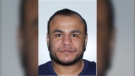
BREAKING Man wanted in connection with deadly shooting in Toronto tops list of most wanted fugitives in Canada
A 35-year-old man wanted in connection with the murder of Toronto resident 29-year-old Sharmar Powell-Flowers nine months ago has topped the list of the BOLO program’s 25 most wanted fugitives across Canada, police announced Tuesday.
Prince William and wife Kate thank public for birthday messages for son Louis
Prince William and his wife Kate thanked the public for their messages which had been sent to mark the sixth birthday of their youngest son Louis on Tuesday.
She was the closest she'd ever been to meeting her biological father. Then life dealt her a blow
Anne Marie Cavner was the closest she'd ever been to meeting her biological father, but then life dealt her a blow. From an unexpected loss to a host of new relationships, a DNA test changed her life, and she doesn't regret a thing.
How quietly promised law changes in the 2024 federal budget could impact your day-to-day life
The 2024 federal budget released last week includes numerous big spending promises that have garnered headlines. But, tucked into the 416-page document are also series of smaller items, such as promising to amend the law regarding infant formula and to force banks to label government rebates, that you may have missed.
Fire engulfs old Edmonton municipal airport hangar
A historical hangar at the former Edmonton municipal airport beside the NAIT main campus was on fire Monday night.
Soft skills, preparation can help new graduates land jobs, experts say
As new graduates enter the workforce over the next few weeks, they are likely to face challenges getting their foot in the door and must be prepared to effectively communicate what they bring to the company.
RCMP uncovers plot to sell drones and equipment to Libya
The RCMP says it has uncovered a ploy to sell Chinese drones and military equipment to Libya illegally.
Shopping Trends
The Shopping Trends team is independent of the journalists at CTV News. We may earn a commission when you use our links to shop. Read about us.


Montreal
-
RCMP uncovers plot to sell drones and equipment to Libya
The RCMP says it has uncovered a ploy to sell Chinese drones and military equipment to Libya illegally.
-
Thieves allegedly attempt to steal thousands of litres of gasoline in Brossard
Two thieves allegedly attempted to steal 'thousands' of litres of gasoline from a Brossard service station.
-
4 vehicles set ablaze in Montreal garage parking lot
Montreal police are investigating after four vehicles were set on fire Monday night.
Ottawa
-

Ottawa to spend $150,000 to study making Mooney's Bay safe for sledding
The City of Ottawa will spend $150,000 to study options to make Mooney's Bay a sledding destination, but staff warn the cost to make the popular hill safe will be high.
-
3 children injured after truck and school bus collide in Russell, Ont.
Three children and a driver were taken to hospital after a school bus and a truck collided on Route 400 in Russell, Ont.
-
Car owner injured after stopping thieves from stealing vehicle in Hawkesbury, Ont.
Ontario Provincial Police are investigating after a vehicle owner intercepted thieves trying to steal their car and suffered "potentially serious injuries."
Northern Ontario
-

One dead after ATV crash in Sault Ste. Marie
A 34-year-old from Sault Ste. Marie has died following a serious crash involving an ATV on Monday afternoon, police say.
-
Mobility scooter burst into flames in northern Ontario
It was a scary sight in northern Ontario Monday morning after an electric mobility scooter caught on fire.
-
Man responsible for northern Ont. crash that killed woman days before her wedding fined $5K
It was a sad scene at Tom Davies Square in Sudbury on Monday morning, where a man was being sentenced for a crash that killed a North Bay woman who was driving to her wedding shower.
Kitchener
-
 DEVELOPING
DEVELOPING Businesses evacuated, roads closed in Guelph
Police have shut down three roads in Guelph’s north end after a suspicious package was found at a Canada Post distribution centre in the area.
-
Suspicious person ringing doorbells in Kitchener, police say
Waterloo regional police are investigating reports of a suspicious male in Kitchener’s Westmount neighbourhood.
-
Charges anticipated in serious Kitchener crash
A 22-year-old woman has been seriously injured in a crash at the intersection of Fischer Hallman Road and Victoria Street South in Kitchener.
London
-

Car fire on Highway 401 sends one person to hospital
The Dutton/Dunwich Fire Department responded to the scene near mile marker 142 between Currie Road and Iona Road, after the vehicle caught fire.
-
Byron’s colony of rare bank swallows facing new threat
Council is be urged to ensure that a plan to redevelop the Byron Gravel Pit also maintains a summer home for its long-time residents — a colony of bank swallows.
-
Missing Clinton man with Down syndrome found by 'Project Lifesaver'
Brian Gray-Hicks likes to be active, and goes for daily walks near his home in Clinton.
Windsor
-

'It’s so sad': Six cars involved in early morning crash
Just before 5 a.m., police were called to the scene of the multi-vehicle crash between on Bruce Avenue between Giles Boulevard and Clinton Street.
-
'Strengthen the Core' revitalization plan unveiled by city and police
A new revitalization plan has been unveiled for downtown Windsor.
-
K9 officer Rolex helps nab commercial break-in suspects
Windsor police say canine Rolex helped arrest two suspects following a break and enter at a commercial property.
Barrie
-
The man who gave us 'Carefree Highway' has a street of his own
Orillia council authorized a bylaw to rename Centennial Drive Lightfoot Drive at its meeting on Monday.
-
Meth, cocaine and fentanyl seized in drug bust in Orangeville.
Provincial police executed a search warrant at a home in Orangeville on Fourth Avenue on Friday.
-
Federal offender frequents Barrie, Midland, Thunder Bay areas: R.O.P.E. Squad
Repeat Offender Parole Enforcement (R.O.P.E.) Squad requesting the public's help in locating a federal offender.
Winnipeg
-
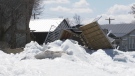
'Never seen this before': Homes in Manitoba community damaged by ice wall
Homeowners in a Manitoba community are cleaning up after being impacted by a natural phenomenon last week.
-
'It's bittersweet': Popular St. Boniface restaurant set to close its doors
Marion Street Eatery is set to close its doors for good after over a decade serving up steaming plates of eggs benedict, grilled cheese and brisket hash.
-
Canada downs Scotland 12-5, remains unbeaten at mixed curling worlds
Canada's Kadriana and Colton Lott scored six in the sixth end to clinch a 12-5 win over Scotland at the world mixed doubles curling championship on Tuesday.
Atlantic
-

People on Halifax Peninsula told to close windows following structure fire
People living on the Halifax Peninsula are being told to close their windows and shut off their air exchangers following a structure fire in the north end of the city Tuesday morning.
-
Rain, showers, late April snow expected in the Maritimes on Wednesday
A weather front from the west and a low-pressure system over the Atlantic will bring a mixture of rain, showers, and even a touch of late April snow to the Maritimes on Wednesday.
-
Youth dead, two suspects in custody following incident near Halifax Shopping Centre: police
A male youth has died after an incident near the Halifax Shopping Centre on Monday.
N.L.
-

Newfoundland director found creeping terror of 'The King Tide' in a tiny coastal town
Newfoundlander Christian Sparkes has shot several films around his home province, but with his new psychological thriller 'The King Tide' he saw an opportunity to wander into one unique town that had eluded him over the years.
-
2 people dead, 4 others make it to shore after vessel capsizes in Newfoundland
The Department of Fisheries and Oceans says two people were found dead and four others survived after a boat capsized off the west coast of Newfoundland.
-
N.L. gardening store revives 19th century seed-packing machine
Technology from the 19th century has been brought out of retirement at a Newfoundland gardening store, as staff look for all the help they can get to fill orders during a busy season.
Edmonton
-

Fire engulfs old Edmonton municipal airport hangar
A historical hangar at the former Edmonton municipal airport beside the NAIT main campus was on fire Monday night.
-
Hyman, McDavid lead Oilers to 7-4 playoff win over Kings
For once the Edmonton Oilers won’t have to dig themselves out of a hole to start the NHL playoffs.
-
Large study shows caribou herds in Alberta, B.C., growing from wolf culls, cow pens
Fresh research suggests western Canada's once-dwindling caribou numbers are finally growing.
Calgary
-

Fire crews extinguish shed fire at northwest Calgary home
No one was injured after a shed fire at a home in northwest Calgary on Monday night.
-
Large study shows caribou herds in Alberta, B.C., growing from wolf culls, cow pens
Fresh research suggests western Canada's once-dwindling caribou numbers are finally growing.
-
Doctors ask Liberal government to reconsider capital gains tax change
The Canadian Medical Association is asking the federal government to reconsider its proposed changes to capital gains taxation, arguing it will affect doctors' retirement savings.
Regina
-

One year after fatal collision, Regina council has final say on lower speed limit in Cathedral
Regina city councillors are set to consider lowering the speed limit in the Cathedral neighbourhood to 30 kilometres per hour on Wednesday.
-
Sask. NDP leader combats claims of carbon tax support following Ottawa visit
Members of the Sask. Party claim a recent trip by the leader of the opposition reveals her party's secret support for the federal carbon tax.
-
Sask. NDP call for education minister's firing, premier reconfirms confidence
The Saskatchewan NDP are calling for the resignation or firing of Education Minister Jeremy Cockrill, saying he lied about apologizing for comments he made to a mother whose daughter died.
Saskatoon
-

Sask. broker says halal mortgages are not a new concept in Canada
A Saskatoon mortgage broker says the federal government’s move to help Muslim Canadians get into the housing market by promoting halal mortgages is not such a radical idea — it’s helping families buy their first home without breaking their faith.
-
Sask. driver caught using vice grips in place of steering wheel
A driver caught using vice grips in place of a steering wheel was ticketed Wednesday after being stopped by police on a rural road.
-
Saskatchewan Rush look to 'better mentality next year' as they miss playoffs again
The Saskatchewan Rush are absent from the National Lacrosse League playoffs for a third straight season, a difficult end to an postseason push born out of a rocky start.
Vancouver
-

Director of B.C. massage school must pay $12K after asking client to 'certify' he's not Muslim
The director of a B.C. massage school has been ordered to pay thousands of dollars for discriminatory comments she made to a Muslim man who wanted to book a treatment.
-
'We wish we could do more': Surrey mayor takes aim at province after budget approval
Surrey city councillors approved the 2024 operating and capital budget on Monday that included a six per cent property tax increase.
-
'Trying not to die': Tourism operators face heavy debt, even as business roars back
Tourism has come roaring back from pandemic lows, but operators say the sector has yet to reach pre-COVID levels and debt remains a hefty burden for thousands of small businesses across the country.
Vancouver Island
-
Police release details about suspect vehicle after fatal B.C. hit-and-run crash
Mounties searching for a driver who struck and killed a woman on Vancouver Island last week released new details about the suspect vehicle Monday.
-
Director of B.C. massage school must pay $12K after asking client to 'certify' he's not Muslim
The director of a B.C. massage school has been ordered to pay thousands of dollars for discriminatory comments she made to a Muslim man who wanted to book a treatment.
-
Search for missing kayakers off Vancouver Island expands into U.S.
Authorities on both sides of the Canada-U.S. border resumed search efforts Monday to find two men who went missing while kayaking off Vancouver Island over the weekend.


