Here's when southern Ontario's 'significant' snowstorm will hit
Winter will be making a major comeback this week with a significant snowstorm set to blast through southern Ontario.
Environment Canada issued a special weather statement from Windsor to Quebec City, warning of a high impact storm arriving Wednesday. Rapidly accumulating snow and reduced visibility could lead to travel concerns.
At the height of the storm, two centimetres of snow could fall per hour in the hardest hit areas.
Toronto, Markham, Hamilton, Ottawa, Peel, London, Niagara, Peterborough, Waterloo, Windsor, and Durham are some of the regions included in the weather statement.
WHAT IS THE STORM'S TIMELINE?
The snow is expected to start on Wednesday morning with a burst of flurries ahead of the actual storm itself, which is anticipated to arrive in the early afternoon.
The worst of the storm is currently forecast to hit Wednesday evening, creating a messy evening commute. In addition to snow, gusty winds are forecast Wednesday, which will reduce visibility for drivers.
By Thursday morning, the snow is expected to taper off, but the morning commute could still be slow depending on how snow-covered the roads are.
Motorists are encouraged to plan ahead for the Wednesday afternoon and Thursday morning commutes, or postpone non-essential travel.
At least 10 centimetres of snow is expected across southern Ontario, with some areas possibly picking up 15 or even 20.
Special weather statements currently in effect are likely to be upgraded to snowfall warnings as the arrival of the storm nears.
So far in January 2023, about 11 centimetres of snow has fallen in Toronto, well short of the monthly average of 30 centimetres.


CTVNews.ca Top Stories

Widow looking for answers after Quebec man dies in Texas Ironman competition
The widow of a Quebec man who died competing in an Ironman competition is looking for answers.
Amid concerns over 'collateral damage' Trudeau, Freeland defend capital gains tax change
Facing pushback from physicians and businesspeople over the coming increase to the capital gains inclusion rate, Prime Minister Justin Trudeau and his deputy Chrystia Freeland are standing by their plan to target Canada's highest earners.
Tom Mulcair: Park littered with trash after 'pilot project' is perfect symbol of Trudeau governance
Former NDP leader Tom Mulcair says that what's happening now in a trash-littered federal park in Quebec is a perfect metaphor for how the Trudeau government runs things.
Fewer medical students going into family medicine contributing to doctor shortage
As some family doctors are retiring and others are moving away from family medicine, there are fewer medical students to take their place.
'My stomach dropped': Winnipeg man speaks out after being criminally harassed following single online date
A Winnipeg man said a single date gone wrong led to years of criminal harassment, false arrests, stress and depression.
Bodies found by U.S. authorities searching for missing B.C. kayakers
United States authorities who have been searching for a pair of missing kayakers from British Columbia since the weekend have recovered two bodies in the nearby San Juan Islands of Washington state.
'It's discriminatory': Individuals refused entry to Ontario legislature for wearing keffiyeh
Individuals being barred from entering Ontario’s legislature while wearing a keffiyeh say the garment is part of their cultural identity— and the only ones making it political are the politicians banning it.
Competition bureau finds 'substantial' anti-competitive effects with proposed Bunge-Viterra merger
The proposed merger of agricultural giants Viterra and Bunge is raising competition concerns from the federal government.
Douglas DC-4 plane with 2 people on board crashes into river outside Fairbanks, Alaska
A Douglas C-54 Skymaster airplane crashed into the Tanana River near Fairbanks on Tuesday, Alaska State Troopers said.
Shopping Trends
The Shopping Trends team is independent of the journalists at CTV News. We may earn a commission when you use our links to shop. Read about us.


Montreal
-
RCMP uncovers alleged plot by 2 Montreal men to illegally sell drones, equipment to Libya
The RCMP says it has uncovered a plot by two men in Montreal to sell Chinese drones and military equipment to Libya illegally.
-
Widow looking for answers after Quebec man dies in Texas Ironman competition
The widow of a Quebec man who died competing in an Ironman competition is looking for answers.
-
Ahead of SAQ two-day strike, CEO confident agreement will be reached
On the eve of a two-day strike at the Societe des alcools du Quebec (SAQ), the president and CEO of the state-owned company says he is confident of reaching an agreement.
Ottawa
-

Reusable container pilot project coming to Ottawa grocery stores
A new federal pilot project is in the works to reduce single-use plastics at major grocery retailers and it's taking place right here in Ottawa.
-
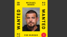
Ottawa murder suspect on list of Canada's top 25 most wanted fugitives
A Toronto man wanted in connection to a double homicide at an Ottawa shopping centre has been named one of the top 25 most wanted fugitives in Canada.
-
Not so fast! Grade 5 students get a firsthand lesson in speeding outside their school
Grade 5 students in Stittsville had class outdoors Tuesday, to see firsthand what traffic is like right outside their school.
Northern Ontario
-

Sudbury police still trying to solve 2022 murder at downtown apartment
Sudbury police are finally releasing the identity of the 50-year-old man who was found shot to death inside his downtown apartment in 2022 as the investigation continues.
-
North Bay doctor accused of assaulting patient, threatening another
A North Bay doctor is facing charges after allegedly assaulting a patient with a weapon and threatening another person at the hospital, police say.
-
BREAKING
BREAKING 'Armed and dangerous' southern Ont. man wanted by Manitoulin police
Police on Manitoulin Island are looking for an 'armed and dangerous' man following an incident involving a firearm on Friday.
Kitchener
-

'My parking is my freedom': Kitchener resident barred from garage despite illness
For Kitchener resident Chris Wilson, indoor parking is much more than a convenient place to leave his vehicle.
-
$50,000 reward issued for Kitchener man’s alleged killer
Habiton Solomon is wanted in the fatal 2023 shooting of Joshua Tarnue in Kitchener.
-
Keffiyeh ban keeps Kitchener woman from entering Queen’s Park
A Palestinian woman from Kitchener is speaking out after she was denied entry into Queen’s Park over a cultural piece of clothing.
London
-

Rail safety advocate shares insight as questions linger over downtown London, Ont. freight train fire
Two days after a freight train with several cars engulfed by flames rolled through the heart of London, a rail safety advocate is speaking out about how changes should be expected.
-
'I’m a survivor': Witness tells jury of escape plan at sexual assault trial
A London, Ont. jury heard evidence on Tuesday of how the children involved in a case of sexual abuse eventually fled their home and contacted police.
-
Candidates pound the pavement in ramp-up to Lambton-Kent-Middlesex by-election
Voters in Lambton Kent Middlesex go to the polls for a provincial by-election in a little more than a week now. When it comes to the key issue of affordability, they seem to be getting an earful from voters.
Windsor
-

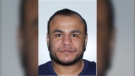
Windsor shooting suspect John Managhan added to Canada’s most wanted list
A Windsor man sought for attempted murder has been named as one of Canada’s most wanted fugitives.
-
Petition urges Transit Windsor to halt bus route relocation, despite city's plan to proceed
Nearly 300 people have signed a petition calling for Transit Windsor to hold off on moving a bus route alongside a residential road in East Riverside — but the city is moving forward with the plan anyway.
-
Videos show suspect vehicle in shots fired investigations
Windsor police and Crime Stoppers have released new videos of a suspect vehicle with hopes of getting more information on recent shootings.
Barrie
-

Man hospatilized with Legionnaire’s disease in 2022 files lawsuit against Orillia and contractors
An Orillia man who was says he was hospitalized for weeks after contracting Legionnaire’s disease in the fall of 2022 has filed a $2.6-million lawsuit against the city.
-
Massive theft ring busted: $300,000 recovered
Barrie police busted a massive theft ring and seized over 300,000 dollars in stolen property.
-
Police search for 11th most wanted person in high-profile abduction case
35-year-old Deshawn Davis is now the 11th most wanted person by police in Canada.
Winnipeg
-

'My stomach dropped': Winnipeg man speaks out after being criminally harassed following single online date
A Winnipeg man said a single date gone wrong led to years of criminal harassment, false arrests, stress and depression.
-
'We always have a thoughtful process for that': The dark reality facing aging zoo animals
Anyone who visits Assiniboine Park Zoo can see empty or near-empty exhibits scattered throughout the grounds – spaces that previously served as homes for aging animals that have since passed away.
-
Winnipeg man bringing his 119-year-old home back to its original glory
When you step through the front door of Matthew Jacobi's 119-year-old home, it's like jumping back through history. For the past year, Jacobi has been restoring his Queen Anne Revival-era home in Winnipeg's North Point Douglas neighbourhood back to its former glory.
Atlantic
-

Police release name of teen who died following incident in Halifax mall parking lot
Halifax Regional Police has confirmed the identity of the teen who died following an incident in the parking lot of the Halifax Shopping Centre Monday.
-
'There was a lot of black smoke': Crane operator sounds alarm while trapped during highrise fire in Halifax
A tower crane operator alerted emergency crews after noticing a fire on a construction site in Halifax Tuesday morning.
-
N.B. mother pushes for age mandate changes at childrens' hospital in light of son’s 16th birthday
A New Brunswick mom is speaking out for her son after learning that after over a decade of care, he is now too old for the IWK in Halifax, which age mandate is 16 years of age for children
N.L.
-

Rideshare platform Uber expands to Newfoundland and Labrador
Uber Technologies Inc. says it has brought its ridesharing platform to Newfoundland and Labrador.
-
Newfoundland director found creeping terror of 'The King Tide' in a tiny coastal town
Newfoundlander Christian Sparkes has shot several films around his home province, but with his new psychological thriller 'The King Tide' he saw an opportunity to wander into one unique town that had eluded him over the years.
-
2 people dead, 4 others make it to shore after vessel capsizes in Newfoundland
The Department of Fisheries and Oceans says two people were found dead and four others survived after a boat capsized off the west coast of Newfoundland.
Edmonton
-

Fire that destroyed historic Hangar 11 is suspicious: EPS
The Edmonton Police Service has confirmed a fire that destroyed a historic hangar in central Edmonton is considered suspicious.
-
High prices? 'Kings fatigue'? Empty seats evident at Oilers' playoff series-opening home-ice win
The Oilers announced a sellout crowd for their 7-4 win over Los Angeles on Monday that opened a first-round playoff series with the Kings. Unoccupied seats, however, were noticeable throughout the arena.
-
Wildfire southwest of Peace River spurs evacuation order
People living near a wildfire burning about 15 kilometres southwest of Peace River are being told to evacuate their homes.
Calgary
-

Calgary police release name of Redstone homicide victim
Calgary police say a woman who died in the community of Redstone over the weekend is the city's seventh homicide of 2024.
-
Liquor sales are a possibility in Alberta grocery stores, but expect pushback
Alberta's alcohol industry is pushing back against a provincial government consideration to allow liquor sales in grocery and convenience stores.
-
Mount Royal University students concerned about stricter parking rules
New parking rules at Mount Royal University (MRU) have some students fired up. Over the past five years, the parking prices at the school have skyrocketed according to some students, and now new rules aim to crack down on parking infringements.
Regina
-

'No better namesake': Veteran support program honours James Smith victim
A new mental health support program for veterans is honouring the life of a Sask. man killed during the mass stabbings on the James Smith Cree Nation.
-
Sask. teachers to hold online meetings prior to deal vote
The Saskatchewan Teachers' Federation said its members are "strongly encouraged" to attend one of two online town hall meetings scheduled to happen prior to a membership vote on a possible deal.
-
'Sweetheart deals': NDP questions gov't involvement in U.S. company taking over Sask. business contract
The provincial NDP is raising questions about the Sask. Party's involvement with a U.S. rubber recycling company gaining a contract held by a Saskatchewan business.
Saskatoon
-

Punched, kicked, spat on: Saskatoon Transit workers call for safety improvements
The union representing the city’s bus drivers says violence against transit workers is out of control.
-
Trudeau to Sask. residents: We're not coming for your carbon rebates
People in Saskatchewan will keep getting Canada Carbon Rebate payments, despite an ongoing feud between Ottawa and the provincial government.
-
'Everybody's getting too old': Saskatoon's iconic Blue Diamond restaurant is up for sale
One of the owners of Saskatoon’s iconic diamond-shaped restaurant says his family is looking to sell the business and building because “everybody’s getting too old.”
Vancouver
-

Mounties will not be charged in shooting death of B.C. Indigenous man
Three Mounties in British Columbia will not face charges in the killing of a 38-year-old Indigenous man on Vancouver Island in 2021.
-
Officials tight-lipped on possible public NHL playoff viewing parties in Vancouver
As Vancouver plays host to Stanley Cup playoff games for the first time in nearly a decade, there is no sanctioned outdoor location for fans to gather and watch the games.
-
B.C. man finds his stolen tools for sale online less than 24 hours after break-in
Mounties in Richmond are praising the victim of a break-in for his "due diligence," which they say helped them recover stolen goods from two investigations.
Vancouver Island
-
Mounties will not be charged in shooting death of B.C. Indigenous man
Three Mounties in British Columbia will not face charges in the killing of a 38-year-old Indigenous man on Vancouver Island in 2021.
-
Bodies found by U.S. authorities searching for missing B.C. kayakers
United States authorities who have been searching for a pair of missing kayakers from British Columbia since the weekend have recovered two bodies in the nearby San Juan Islands of Washington state.
-
Vancouver Island man looking to set 3 Guinness World Records on an electric mountain board
Bradley Smith has been electric skateboarding for the past nine years, a passion he says was "addictive" from the first time he tried it.


