Toronto is on track to shattering several weather records after spending nearly a month in the grip of bitter cold and Arctic wind.
According to Environment Canada, cities including Toronto, Kitchener-Waterloo, Peterborough, Kingston and Barrie have remained below freezing since January.
"This will set the stage for the first time an entire calendar month has been below freezing in the Kitchener and Toronto Pearson airport areas since February 1978," a statement released Monday said.
Monday and Tuesday were the coldest Feb. 23 and 24 on record, with temperatures reaching -21.6 and -20.4. The previous record for Feb. 23 was -19.4 in 1972.
The coldest Feb. 24, prior to this year, was in 1993, when temperatures reached -19.4.
On both days, wind chills reached between -30 and -40, meaning exposed skin could freeze in 10 minutes.
Last winter, the City of Toronto called 36 extreme cold weather warnings, the highest number of warnings in 10 years. So far this year, the city has called 34 alerts, and the official start of spring is still three weeks away. Two-thirds of the alerts were called in February, with alerts only called off on Feb. 6 and 7.
On Friday morning, Environment Canada issued an extreme cold weather warning for most southern Ontario, including Toronto. The warning was dropped shortly after 10 a.m., though temperatures remained cold.
"Yet another frigid Arctic airmass will combine with light to moderate winds to produce wind chill values between -30 and -35 this morning," the national weather agency wrote.
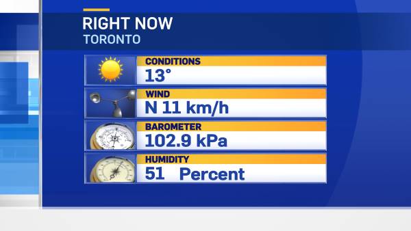
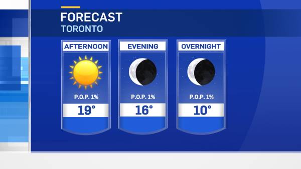
As of 7 a.m., it was -20 in Toronto, but felt more like -27 with the wind chill. The temperature is supposed to warm up slightly as the sun rises, and the mercury will climb to -10 by 4 p.m., Environment Canada predicts. It will feel like -18 with the wind chill.
Overnight, the temperature will drop back to -19, with a wind chill feeling like -26 by Saturday morning.